Dramatic reductions in water flow in the Tarim River, the lifeblood of Xinjiang Province, mean provincial authorities must act fast to conserve water and find alternative water sources.
ÜRÜMQI, CHINA—The Tarim River is the lifeblood of Xinjiang Province, providing more than half the irrigation water for this Alaska-sized region in western China. The largest inland river in Asia, the Tarim is also a green-fringed stockade keeping the vast Takla Makan Desert from advancing northward into rugged grasslands and fertile oases inhabited by the majority of the province's 20 million people. With Xinjiang's fortunes riding on the Tarim, officials watched with growing dismay last winter as the river's volume fell 28% below average and 300 kilometers of its 1321-kilometer-long course ran dry. After enjoying 2 decades of robust flow, water managers in May ordered strict rationing through September.
One group of researchers saw the crisis coming. Based on past flow rates and weather conditions anticipated for 2007–08, Chen Yaning and colleagues at the Chinese Academy of Sciences' Xinjiang Institute of Ecology and Geography in Ürümqi forecast a sharp drop in runoff feeding the Tarim. Their report in the 20 March issue of Hydrological Processes predicted that the river will bounce back this coming winter. But if their numbers are correct, another—and worse—crisis will happen in 2009–10, when the Tarim's inputs are predicted to be 12% less than the past year's poor flow. “Most farms will not be able to irrigate their crops,” says Chen, who calls the looming threat “a big conflict between ecology and the economy.”
The long-term prognosis is cloudier. On one hand, Xinjiang has been getting wetter over the past half-century, and models suggest that precipitation will continue to increase, says Ye Qian, a climate expert at the National Center for Atmospheric Research in Boulder, Colorado. But as the world warms, glaciers in the Tian Shan and Kunlun mountain ranges encircling the Tarim Basin are retreating, and the Tarim's fate is tied to its glacier-fed tributaries. “If the glaciers disappear, so will the source of the Tarim's water,” says Liu Changming, a hydrologist at the Institute of Geographical and Natural Resources Research in Beijing. Rising temperatures will also increase freshwater loss through evaporation.
This is not the first watercrisis to grip Xinjiang. In recent decades, the Tarim's nine historical tributaries have dried up one by one, leaving just three: the Aksu, the Yarkand, and the Hotan rivers. (Last winter, the Yarkand and Hotan stopped flowing altogether, only resuming in May with spring runoff.) Worried by the high evaporation rates as the Tarim neared its terminus, Chinese engineers in the early 1970s dammed the river to create the Daxihaizi Reservoir. The amputation dried up the Tarim's final 321 kilometers, turning villages downstream into ghost towns. In the meantime, the “green corridor”—a marshy vegetation belt extending 800 or so meters on either side of the Tarim—began to wilt as water diversion to Daxihaizi and smaller reservoirs drew down the water table. Since 2000, the central government has spent roughly $15 million shoring up this line of defense against the Takla Makan.
All signs indicate that provincial authorities must act fast to conserve water. Unbridled irrigation in the Tarim's upper reaches, Chen says, sucked the life from tributaries and caused rampant salinization that has ruined 1.1 million hectares of farmland, a quarter of Xinjiang's total. Water-saving steps could include switching from ditch irrigation to drip irrigation and moving away from water-intense crops.
The grand challenge is to find alternative water sources. Chen's group plans to team up with Wang Chi-Yuen of the University of California, Berkeley, to hunt for hidden aquifers. As a first step, they will chart features—such as limestone karst formations—likely to hold water. “There must be large aquifers in the mountains,” Chen says. Xinjiang's future may depend on it.
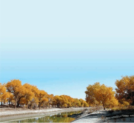
Thin green line.
The Tarim River keeps the Takla Makan Desert at bay and irrigates much of Xinjiang's cropland.